Wednesday, April 12, 2006
Gander Weather forcasting reinstated

I hate to be a stick in the mud BUT while I am pleased to hear the Tories have seen fit to return the status quo for Newfoundland (Labrador) weather forcasting.
IE: 20 personel, Aircraft weather forcasting, Marine forcasting, and land forcasting.
The data these individuals will have to work with hasn't changed. With the exception of looking out the window and forcasting for their own back yard in and around Gander.
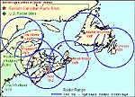
Personally I would have been just as pleased if not more so if they had saw the errors of their forcasting in that there are only two Doppler radars in all of Newfoundland (Labrador excluded because Labrador doesn't have any Doppler Radars)
When you look at the rest of Canada you will notice that the Doppler Radars are spaced some 200 kilometres distant in several cases and in some like Vancouver And Vancouver Island they are only 100 km distant completely overlapped.
If you look at the Maritimes their Doppler Radars are spaced some 200 km distant overlapped some 400 km in all.
Now what do doppler radars do exactly you might ask well I'm no expert but from what I've researched and read they detect particulate in the air and are also able to detect micro climates. If you look at the Doppler radars in the USA they are all just the 200 km distant because it would appear beyond the 200 km range their accuracy decreases dramatically especially if the terrain is rough.
Personally I say sure return the forcasters but we need more Doppler radars many more in my estimation. I would say we need one at Port Aux Basques, Gander/Grandfalls, St John's, St Anthony, Happy Valley Goose Bay, Labrador City and if money isn't an option Nain.
Give us Doppler radars in all of these locations and you can keep you 20 forecasters. There are three Doppler radars N/O Non/Operational across Canada for whatever reason One on the Island of Vancouver, Which IMHO is the only one that could be removed without any effect on the forcasting in that area.
Unlike the rest of Canada where all of the work is done by LandLubbers In NL alot of our work and business goes on on the sea and in a very hazardous enviroment. Remember the Ocean Ranger, hey maybe they could put a Doppler radar on the oil rigs.
Also of note this map from Enviroment Canada is so grossly tilted to the west to make Eastern Canada look like it is further North than it actually is it's no wonder they have been getting the forcasts wrong. Geez if I didn't have my tin foil hat on I'd say they did it on purpose because nobody in their right mind could so grossly represent a map of the earth unless of course the werer falling over drunk and looking at it from an inebriated stupor on the floor.
Comments:
<< Home
When you look at the rest of Canada you will notice that the Doppler Radars are spaced some 200 kilometres distant in several cases and in some like Vancouver And Vancouver Island they are only 100 km distant completely overlapped.
Yip.
They are closer together in BC because of the mountainous terrain. And they are closer together on the Prairies because of the higher tornado risk.
Otherwise, the two in Newfoundland are pretty well average in terms of spacing.
Now what do doppler radars do exactly you might ask well I'm no expert but from what I've researched and read they detect particulate in the air and are also able to detect micro climates.
Micro climates?
Meteo radars are used to identify the type, intensity, location, and movement of precipitation in the atmosphere.
If you look at the Doppler radars in the USA they are all just the 200 km distant because it would appear beyond the 200 km range their accuracy decreases dramatically especially if the terrain is rough.
That, and the U.S. has elevated population densities over more of its landmass than Canada, and the worst tornado belt in the world.
Personally I say sure return the forcasters but we need more Doppler radars many more in my estimation. I would say we need one at Port Aux Basques, Gander/Grandfalls, St John's,
St. John's is perfectly adequately covered by Holyrood; almost the entire island is visible on either the Holyrood or Marble Mountain radar.
St Anthony, Happy Valley Goose Bay, Labrador City and if money isn't an option Nain.
Money is an obstacle; there's a cost-benefit factor with these critters. That may come down over time.
There are three Doppler radars N/O Non/Operational across Canada for whatever reason One on the Island of Vancouver, Which IMHO is the only one that could be removed without any effect on the forcasting in that area.
You have no idea about the terrain in that area, then.
The radar sites have to go down from time to time for maintenance, and, in some cases, they get knocked out by the weather itself. I've seen that happen with the King City and Franktown sites before.
Unlike the rest of Canada where all of the work is done by LandLubbers In NL alot of our work and business goes on on the sea and in a very hazardous enviroment.
How is that different from the Maritimes, maritime Quebec, BC, or the Great Lakes? NL is hardly the only province where many people work on the water.
Remember the Ocean Ranger, hey maybe they could put a Doppler radar on the oil rigs.
To what end?
Also of note this map from Enviroment Canada is so grossly tilted to the west to make Eastern Canada look like it is further North than it actually is
You are still confusing north with up.
The two are not the same.
Post a Comment
Yip.
They are closer together in BC because of the mountainous terrain. And they are closer together on the Prairies because of the higher tornado risk.
Otherwise, the two in Newfoundland are pretty well average in terms of spacing.
Now what do doppler radars do exactly you might ask well I'm no expert but from what I've researched and read they detect particulate in the air and are also able to detect micro climates.
Micro climates?
Meteo radars are used to identify the type, intensity, location, and movement of precipitation in the atmosphere.
If you look at the Doppler radars in the USA they are all just the 200 km distant because it would appear beyond the 200 km range their accuracy decreases dramatically especially if the terrain is rough.
That, and the U.S. has elevated population densities over more of its landmass than Canada, and the worst tornado belt in the world.
Personally I say sure return the forcasters but we need more Doppler radars many more in my estimation. I would say we need one at Port Aux Basques, Gander/Grandfalls, St John's,
St. John's is perfectly adequately covered by Holyrood; almost the entire island is visible on either the Holyrood or Marble Mountain radar.
St Anthony, Happy Valley Goose Bay, Labrador City and if money isn't an option Nain.
Money is an obstacle; there's a cost-benefit factor with these critters. That may come down over time.
There are three Doppler radars N/O Non/Operational across Canada for whatever reason One on the Island of Vancouver, Which IMHO is the only one that could be removed without any effect on the forcasting in that area.
You have no idea about the terrain in that area, then.
The radar sites have to go down from time to time for maintenance, and, in some cases, they get knocked out by the weather itself. I've seen that happen with the King City and Franktown sites before.
Unlike the rest of Canada where all of the work is done by LandLubbers In NL alot of our work and business goes on on the sea and in a very hazardous enviroment.
How is that different from the Maritimes, maritime Quebec, BC, or the Great Lakes? NL is hardly the only province where many people work on the water.
Remember the Ocean Ranger, hey maybe they could put a Doppler radar on the oil rigs.
To what end?
Also of note this map from Enviroment Canada is so grossly tilted to the west to make Eastern Canada look like it is further North than it actually is
You are still confusing north with up.
The two are not the same.

Subscribe to Post Comments [Atom]
<< Home
![]()
Subscribe to Posts [Atom]
